Princes' Islands History
- Published Date
- 10 March 2026, 09:20
Tour Organizer
- Published Date
- 10 March 2026, 09:20
- Category
- Blogs
Discover the Princes Islands of Istanbul
Just a short journey from the vibrant streets of Istanbul lies a peaceful archipelago known as the Princes Islands. Located in the Sea of Marmara, southeast of the Bosphorus, these islands have long served as Istanbul’s seaside escape, offering nature, history, and tranquility only a ferry ride away.
Although the islands are only 15 to 26 kilometers from Istanbul, the atmosphere feels worlds apart. The noise of the city fades away, replaced by quiet streets, pine forests, historic mansions, and breathtaking sea views. For centuries, the Princes Islands have been a retreat for residents of Byzantine Constantinople, the Ottoman Empire, and modern-day Istanbul.
The archipelago consists of nine islands, but only a few are inhabited and regularly visited. The main islands open to visitors are:
-
Kınalıada (Proti) - the closest island to Istanbul
-
Burgazada (Antigoni)
-
Heybeliada (Halki)
-
Büyükada (Prinkipos) - the largest and most famous island
During the summer season, ferries also stop at Sedef Island, while smaller islands such as Kaşık Island, Tavşan Island, Yassıada, and Sivriada remain mostly uninhabited.
Each island has its own unique character, offering visitors different landscapes, historic landmarks, and hidden corners waiting to be explored.
Büyükada - The Crown of the Princes Islands
Büyükada, historically known as Prinkipos, is the largest and most iconic island of the archipelago. It is also the most visited destination among the Princes Islands and a favorite summer getaway for both locals and international travelers.
With an area of 5.4 square kilometers, Büyükada is larger than the other main islands combined. The island has around 6,500 residents during the year, but during the summer months this number can rise to 40,000 visitors and seasonal residents.
The island stretches approximately 4.3 km from north to south and about 1.3 km from east to west. Two prominent hills dominate the landscape:
-
Isa Hill (Hristos Hill) in the north, rising to 164 meters
-
Yüce Tepe (Saint George Hill) in the south, reaching 202 meters, the highest point on the island
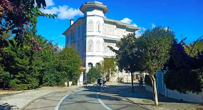
The northern part of Büyükada features lively streets, elegant historic villas, and charming seaside cafés. As you travel south, the scenery becomes more natural and dramatic, with pine forests, rocky cliffs, and quiet beaches overlooking the Sea of Marmara.
At the top of Yüce Tepe stands the famous Aya Yorgi Church, one of the island’s most visited landmarks, offering stunning panoramic views of the surrounding islands and sea.
Heybeliada - A Green Island with Rich History
Heybeliada, the second-largest island of the archipelago, covers an area of 2.35 square kilometers. It has a population of around 5,500 residents, which increases significantly during the summer months.
The island’s Greek name Halki, meaning copper, comes from the copper mines that were once operated here in ancient times. Even the philosopher Aristotle mentioned these mines in historical writings.
The Turkish name Heybeliada comes from the unique saddle-like shape of the island’s hills and valleys.
The island is surrounded by several hills, including:
-
Ümit Hill (formerly Papaz Mountain)
-
Değirmen Hill
-
Köy Hill
-
Baltacıoğlu Hill
Most of the island’s town area is located along the northeastern coast, where traditional island houses are scattered across the hillsides and valleys. Heybeliada is known for its lush forests, relaxed atmosphere, and scenic walking routes, making it a favorite for visitors who enjoy nature and quiet exploration.
Burgazada - A Charming and Authentic Island
Burgazada is the third-largest island in the Princes Islands archipelago, covering about 1.5 square kilometers. Its year-round population is around 1,500 residents, but during the summer season this number grows to approximately 15,000 visitors and seasonal residents.
In ancient times, the island was known as Panormos, and during the Byzantine period it became known as Antigoni, a name still used by the Greek community.
The modern Turkish name Burgazada is believed to come from the Greek word “Pyrgos,” meaning “tower.” Historical travelers, including the famous Ottoman explorer Evliya Çelebi, wrote about a watchtower that once stood on the highest point of the island.
Today, that highest point is Bayraktepe, also known as Hristos Hill, rising 170 meters above sea level. From here, visitors can enjoy spectacular views of the surrounding islands and the Marmara Sea.
The island’s small village center is located along the northeastern coast, with charming streets spreading toward the hills above. Burgazada is known for its authentic island atmosphere, quiet beaches, and relaxed seaside lifestyle.
Experience the Princes Islands with a Guided Tour
Exploring the Princes Islands is one of the most memorable experiences visitors can have in Istanbul. From historic monasteries and Ottoman-era mansions to pine forests and hidden beaches, the islands offer a unique blend of nature, culture, and history.
Whether you prefer cycling through quiet streets, swimming in crystal-clear waters, or discovering historic landmarks with a knowledgeable guide, a Princes Islands tour is the perfect way to experience these beautiful destinations.
For more information about our full-day Princes Islands tour and private island experiences, feel free to contact us.
WhatsApp: +90 537 213 26 93


